A six-story mixed-use project off J Street last fall hit groundwater three feet earlier than the geotechnical baseline predicted. The contractor had shoring in place, but the real concern was the 1920s brick building next door. Within two hours we had an automated total station tracking prisms on that facade and vibrating wire piezometers reading pore pressure every fifteen minutes. Sacramento's downtown grid is full of aging unreinforced masonry, and deep excavation here isn't just a soil mechanics problem—it's a neighborhood stability problem. We combine real-time inclinometer arrays with deformation targets to catch lateral movement before a crack ever appears. For sites near the Sacramento River where silty sands dominate, correlating monitoring data with SPT drilling logs gives us the full picture of what the ground is actually doing versus what the lab predicted.
Monitoring isn't about collecting data—it's about knowing which half-inch of movement closes a street and which one is just the steel warming up.
Scope of work in Sacramento
Risks and considerations in Sacramento
IBC Chapter 33 and OSHA Subpart P require a monitoring program when excavations exceed 20 feet or when adjacent structures are within a zone of influence—and in Sacramento's Midtown and Land Park, that means nearly every multifamily project. The risk isn't theoretical. The city sits on Pleistocene-age alluvial fans where stiff silts and clays alternate with loose sand lenses; a dewatering misstep in a sand lens can trigger rapid settlement. We've seen a 1920s apartment on T Street tilt 1.5 inches in three days because an unmonitored excavation undercut the capillary fringe that had been holding the foundation soil together for a century. ASCE 7-22 Section 12.13.9 also ties monitoring to seismic performance—in a city with a known liquefaction hazard in the Natomas and Pocket areas, post-earthquake excavation inspection protocols are mandatory. Our approach is to establish baseline readings during preconstruction, define action levels with the structural engineer of record, and automate alerts so the crew isn't relying on someone remembering to check a gauge at the end of the day.
Our services
Every excavation in Sacramento presents a different risk profile depending on the neighborhood geology. Our monitoring packages are built around the specific hazard—lateral movement in downtown clay, base heave in deep cuts, or groundwater migration near the levees.
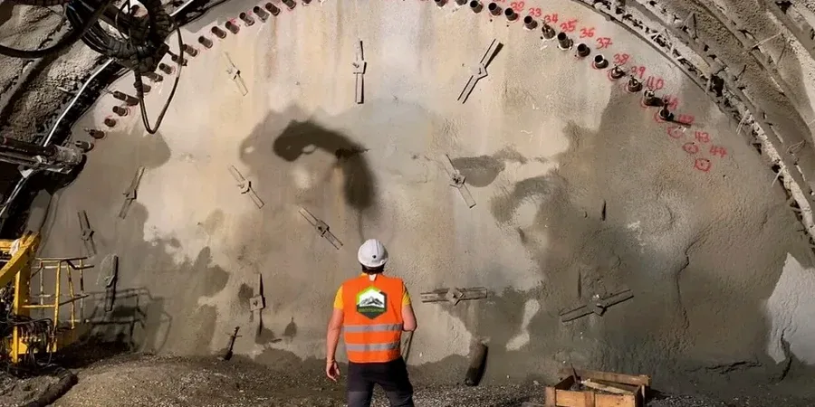
Automated Structural Monitoring for Adjacent Buildings
Total station networks with prism targets and tiltmeters installed on pre-1933 URM buildings, coupled with real-time web dashboards. We set yellow alerts at 50% of allowable movement and red alerts with automatic notification to the contractor, shoring designer, and city inspector.
Deep Excavation Instrumentation and Dewatering Verification
Inclinometer strings behind soldier pile and lagging walls, multiple-level vibrating wire piezometers, and settlement arrays extending two times the excavation depth into the right-of-way. Data correlated daily with the geotechnical baseline report to verify design assumptions.
Quick answers
What's the typical cost for excavation monitoring on a Sacramento infill project?
For a typical mid-rise infill excavation in the central city—say 20 to 30 feet deep with two adjacent structures to monitor—instrumentation and monitoring over a 4- to 6-month excavation period generally falls between US$900 and US$2,840 per month, depending on the number of monitoring points, whether automated total stations or manual readings are required, and the reporting frequency.
Do we need monitoring if we're only digging 15 feet deep?
OSHA requires a competent person inspection for all excavations, but formal instrumentation is not automatically mandated at 15 feet. However, if your 15-foot cut is within a horizontal distance equal to the depth from a neighboring structure—especially, as is common in Sacramento, an older unreinforced masonry building—the IBC and the structural engineer of record will almost certainly require crack gauges and settlement monitoring as a condition of the permit.
How often do you take readings during monitoring?
Depends on the phase. During initial excavation and tieback installation, automated systems read every 15 to 30 minutes. Once the cut reaches final grade and movement stabilizes, we step down to hourly or daily readings. After a significant rain event—not uncommon in Sacramento's winter—we increase frequency again because wetting of the soils behind the shoring can temporarily increase lateral pressure.
Can your monitoring system integrate with our existing site safety protocols?
The reference range for this service in Sacramento is US$900 - US$2.840. The final price depends on the project scope and volume.